


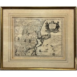
China Veteribus Sinarum Regio nunc Incolis Tame dicta 中国地図
著者: (Switzerland)(瑞)Matthäus Merian
A Latin map produced in the mid-17th century, created by Matthäus Merian and published around 1652 in Frankfurt, Germany.
This map is a later engraving based on the Chinese map re-engraved by Jan Jansson in 1636, which itself was derived from an original map by Willem Blaeu. Compared with earlier maps by Abraham Ortelius (1570) and Jodocus Hondius (1606), this example presents more accurate outlines of the continent and surrounding islands.
Framed (52 × 44 cm); frame with some wear.
17世紀中頃に描かれたラテン語地圖で、Matthäus Merianによって作成され、1652年頃にドイツのフランクフルトで出版された。本圖は、Willem Blaeuの原圖を基に、1636年にJan Janssonが再刻した中國地圖を翻刻したもので、Abraham Ortelius(1570年)やJodocus Hondius(1606年)の初期の地圖に比べ、大陸や島々の輪郭がより正確になっている。
額裝入(52×44cm)、額イタミ。


メールアドレスを入力
してお申込みください。
 小川町本店
小川町本店 神保町店
神保町店


